


Voilà Réal Safari

fra_depoorter
User

Length
46 km

Max alt
166 m

Uphill gradient
740 m
Km-Effort
56 km

Min alt
-2 m

Downhill gradient
717 m
Boucle
No
Creation date :
2023-10-25 09:00:41.605
Updated on :
2023-10-25 12:31:14.733
3h30
Difficulty : Very easy

FREE GPS app for hiking
 SityTrail
IGN / Geographical institutes
SityTrail Plus
The world is yours!
About
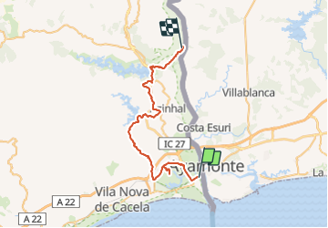
Trail 4x4 of 46 km to be discovered at Algarve, Faro, Vila Real de Santo António. This trail is proposed by fra_depoorter.
Positioning
Country:
Portugal
Region :
Algarve
Department/Province :
Faro
Municipality :
Vila Real de Santo António
Location:
Unknown
Start:(Dec)
Start:(UTM)
640508 ; 4118391 (29S) N.
Comments